Creat and Nominate Resource
Resource Center supports nominating your uploaded data, published services, and works created in WebApps. In the Resource Center, you can create resources and nominate resources.
Creat Resources
In Resource center, it supports to nominate data, services, maps, mapdashboards, insights, and scenes.
-
Data Resources
You can upload data in the Resource Center, click 'Start Creating' > 'Upload Resources' > 'Data' to upload data resources. Click to view detailed operation steps. -
Service Resources
You can publish your service to the Resource Center, click 'Start Creating' > 'Upload Resources' > 'Data', and select 'Upload and publish' on the 'Upload data' page to create service resources. Click to view detailed operation steps. -
Map Resources
You can use Dataviz or MapStudio WebApp to create map resources.
- DataViz
You can upload Excel, CSV, GeoJSON and Shapefile files as feature layers, and add them on the basemap;
You can also add data or REST services you published to DataViz, and the map you created can be used on the web through Cloud storage API.
Thus you can combine your needs and data to create a variety of thematic maps. Click to learn more. - MapStudio
You can create maps by uploading files in MapStudio, or directly using the data and services you uploaded or published to cloud storage. You can visualize and analyze spatial data in MapStudio. Click to learn more.
- DataViz
-
Insights Resources
You can use DataInsight to create insight resources:
- DataInsights
You can upload Excel, CSV, GeoJSON, Shapefile data to DataInsight;
You can also add data or REST services to DataInsight;
Based on the added data or services, you can proceed visualize representation using maps or charts. Click to learn more.
- DataInsights
-
MapDashboard resources
You can use MapDashboard to create resources:
- MapDashboard
Support to use Public Data, My Data, iServer REST Service, etc. as the data source of the visualization component. Click to learn more.
- MapDashboard
-
Scene Resources
You can use iEarth to create scene resources:
- iEarth
You can add the REST 3D service that have been published by hosted data to the scene in the form of layer. Thus you can add point, line and polygon elements based on this scene, or perform measurement, spatial analysis or query functions in the scene. Click to learn more.
- iEarth
Nominate Resource
The finished resources can be found in the 'Resource Center' > 'My Resources'. Click 'nominate' button on the resource card, fill in the following information, and click 'Submit' to apply for nominating.
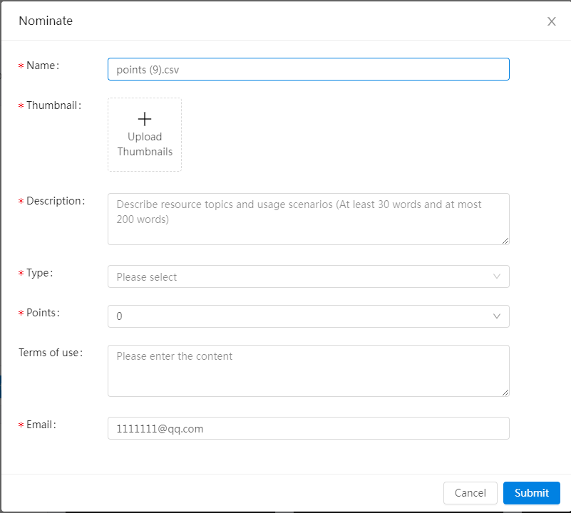
We will review your submitted resources within two working days. The resources successful nominated will no longer occupy your quota, and you can also receive bonus points, click to see more rewarded. If your resources fail to nominate, we will send email of failure reason to the mailbox you filled in on the Nominate page. You can modify resources and apply for nominating again.
Resource Content Review Standard Reference:
| Type | Requirement | Explain |
|---|---|---|
| Data | 1. Basic requirements | It has content and does not duplicate with existing content, and it can be downloaded |
| 2. Topology error | No obvious topology errors, such as suspended lines, non-closed polygons, broken polygons, etc. | |
| 3. Data layering | Hierarchical reasonable specification, in line with the map expression requirements | |
| 4. Scale | Correct use of different scale data | |
| 5. Coordinate system | The data location is correct and the coordinate system is used in a standard way | |
| Service | 1. Basic requirements | It has content and does not duplicate with existing content, and it can be accessible |
| Map | 1. Basic requirements | It has content and does not duplicate with existing content, and it can be accessible |
| 2. Map topic | The theme is clear, and the content is as plain as print | |
| 3. Data processing | The data on the map is well detailed and clearly layered | |
| 4. Drawing symbol | Point, line, polygon symbols are appropriate, and thematic map type is appropriate | |
| 5. Map color | The map color is soft and beautiful, in line with the industry usage habits | |
| 6. Text tag | Have the necessary text labels, and the text is neat and legible | |
| 7. Display performance | High operation efficiency | |
| DataInsights | 1. Basic requirements | It has content and does not duplicate with existing content, and it can be accessible |
| 2. Insight topic | The theme is clear, and the content is as plain as print | |
| 3. Element types | It contains one statistical chart at least | |
| 4. Insight color | The overall color is unified and harmonious | |
| MapDashboard | 1. Basic requirements | It has content and does not duplicate with existing content, and it can be accessible |
| 2. Dashboard topic | The theme is clear, and the content is as plain as print | |
| 3. Element types | It contains two types of dashboard elements at least, including: maps, statistics, tables, pictures, etc. | |
| 4. Dashboard color | The overall color is unified and harmonious | |
| 5. Overall layout | Reasonable and complete layout | |
| iEarth | 1. Basic requirements | It has content and does not duplicate with existing content, and it can be accessible |
| 2. Scene topic | The theme is clear, and the content is as plain as print | |
| 3. Scene color | The scene color is soft and beautiful, in line with the industry usage habits | |
| 4. Text tag | Have the necessary text labels, and the text is neat and legible | |
| 5. Display performance | High operation efficiency |