Concepts: Map Projection and Coordinate System
What is Map Projection?
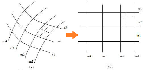
Map projection is a series of theories and methods to convert the longitude and latitude coordinates to the earth's surface plane coordinates by a certain mathematical method.
Why needs Map Projection?
The earth is a sphere, its surface is composed of curved surfaces, but usually we need to draw the map in the plane drawings, so it's needed to convert it to plane surfaces. We must adopt special methods to spread the curved surface, make it a plane without cracking or fold, hence there is the theory of map projection and projection method.
What's Coordinate System?
The coordinate system is used to determine the position of any point on the earth. The map uses different projection methods, and its corresponding coordinate system is also different.
The following are the supported coordinate systems and related codes of SuperMap Online:
| Coordinates system | Code | Supported maps |
|---|---|---|
| GPS latitude and longitude | 4326 |
Tianditu |
| GPS Mercator | 3857 |
Tianditu |
| Navinfo, AutoNavi latitude and longitude | 910101 |
SuperMap Cloud, Navinfo and AutoNavi |
| Navinfo, AutoNavi Mercator | 910111 |
SuperMap Cloud, Navinfo and AutoNavi |
| Baidu latitude and longitude | 910102 |
Baidu |
| Baidu Mercator | 910112 |
Baidu |
Configure coordinate system on SuperMap Online
For example: if the data with WGS84 is expected to overlay with SuperMap Cloud map or Tianditu, Baidu Maps, Navinfo map, firstly upload the data to "My data" and publish it as REST map or data service, then choose target coordinate system for dynamic map outputting or data query, and then overlay the output map or queried data with the related basic map.